![j0431167[1]](SCIESU15Plate_Tectonics_a_image003.jpg)
PLATE
TECTONICS
Unit Overview
In this unit we will learn
about what the continents sit on and how they move. We will also explore the
process on how many of earth’s landforms are created and how the rock cycle
connects to all of these processes.
Earthquakes and
Volcanic Eruptions
On May 18, 1980, Mount St.
Helens, in the state of Washington, erupted explosively sending tons of
volcanic ash and dust into the air and causing massive destruction in its path.
Hot ash and rocks started forest fires and melted the snow on the upper slopes
of the mountain side. This caused floods and mud slides that wiped out
buildings and roadways. The explosion flattened millions of trees, scattering
them like toothpicks. The volcanic ash fell from the sky and formed thick
layers over a wide area many miles away. This destroyed crops and wildlife
while blanketing homes, businesses and roads with a fine, choking dust that
took weeks to haul away. In all, 57 people died and millions of dollars of
damage was done to the surrounding area.
In the late afternoon of
October 17, 1989, the fans and players of the San Francisco Giants and Oakland
A’s were preparing for the start of a World Series game to be held at
Candlestick Park in San Francisco when a massive earthquake struck the area. As
the shock waves of the quake rippled through the crust, the ground rose and
fell like waves in an ocean. Buildings cracked, some fell and fires broke out
as underground gas mains exploded. The death toll reached 43, with most of the
casualties occurring when a large portion of the nearby double-decker freeway
collapsed. The earthquake also caused millions of dollars of property damage
including sufficient damage to Candlestick Park so that the World Series games
had to be scheduled elsewhere.
![]() What Is It
Like Below the Surface of the Earth? (01:17)
What Is It
Like Below the Surface of the Earth? (01:17)
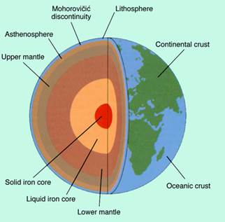
Both earthquakes and volcanic
eruptions occur because the outer shell of the earth is broken into 30 large,
rigid sections called TECTONIC PLATES.
These plates vary in size. The continents are embedded in the tops of these
plates, and some plates carry both continents and ocean floor. There are continental
plates and oceanic plates. The continental plates are made of light continental
crust. Oceanic plates are made of very dense oceanic crust. All of the tectonic
plates make up the earth’s LITHOSPHERE. A
layer of molten rock at temperatures between 2400oF and 3600oF
under the plates is called the ASTHENOSPHERE.
![]() What Are the
Lithosphere and the Asthenosphere? (01:17)
What Are the
Lithosphere and the Asthenosphere? (01:17)
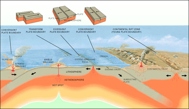
As the plates move on the
asthenosphere they interact with each other at their boundaries. There are
three types of boundaries. The first boundary type is CONVERGENT. This is when one edge of a plate sinks under the edge
of a neighboring plate. This process is called SUBDUCTION.
![]() What Is Plate Tectonics?
(00:50)
What Is Plate Tectonics?
(00:50)
The second boundary type is DIVERGENT. Here, plates separate away
from each other and new lithosphere forms. When this separation occurs on
continents, it is called RIFTING and
creates gaps into which water flows to form major waterways like rivers and
lakes. When rifting occurs on the ocean floor, it is referred to as SEA-FLOOR SPREADING. Scientists have
measured as much as one square mile of new ocean crust per year from this
process. Since the overall size of the lithosphere has not increased,
scientists’ reason that the same amount of crust is destroyed at SUBDUCTION ZONES as is formed by
rifting. Earthquakes and volcanoes occur at both of these types of boundaries.
The third boundary type is
called a TRANSFORM PLATE BOUNDARY.
Plates slide horizontally against each other, neither creating nor destroying
lithosphere. This sliding motion is very slow and continuous. Tremendous
pressures build up in these regions and sometimes “snap” releasing enormous
amounts of stored energy through the crust. Powerful earthquakes, like the ones
described earlier in the lesson, occur along these plate boundaries also called
FAULTS. The transform fault in
California is known as the
![]() In What Ways Do
the Major Plates Move? (01:25)
In What Ways Do
the Major Plates Move? (01:25)
Developments in technology
over the last 100+ years have produced devices to provide better detection of
the earth’s movements. In 1893, John Milne invented a SEISMOGRAPH to detect and measure seismic waves, the waves of
energy that ripple through the crust during an earthquake. The record of waves,
called SEISMOGRAMS, is used to
calculate the strength of an earthquake. Charles Richter, an American
seismologist, developed a scale in 1935 to rank the magnitude of the strength
of an earthquake. Each number on this scale represents ground motion ten times
greater than the next lower number. The highest recorded magnitude of an
earthquake was as 8.3 on the RICHTER
SCALE.
![]() How Does
Plate Movement Generate Earthquakes? (01:43)
How Does
Plate Movement Generate Earthquakes? (01:43)
Laser beams have also been
used to accurately measure the movements along a fault. The amount of time it
takes for a laser beam to strike a reflector and bounce back can detect subtle
movements of the crust. Scientists use this data along with observations of
water levels in wells, changes in the tilt of the earth’s surface and even
changes in animal behavior to predict earthquake and volcanic activity. Better
detection methods will allow for better warning systems to save lives and
property.
![]() How Does
Plate Movement Generate Volcanoes? (01:01)
How Does
Plate Movement Generate Volcanoes? (01:01)
Based on a map prepared by the U.S.
Geological Survey.
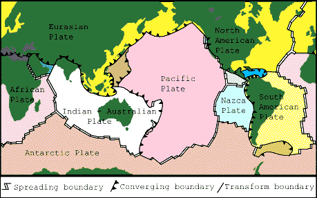
The outer surface of the earth is
made of 12
major plates and several smaller plates. These plates move towards each other (convergent boundaries), away from each
other (spreading or divergent boundaries) or slide past each other (transform
boundaries). Volcanoes are associated with convergent boundaries, where ocean
plates are subducted
under ocean or
continental plates, with spreading boundaries, where new ocean plates are
created, and with hot spots.
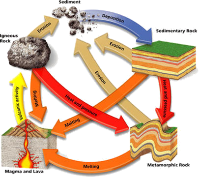
The ROCK CYCLE is how rock can change throughout earth’s crust. Throughout all the boundaries and types of
movements through tectonic plates you can see rock in all its forms. Since it is a cycle we can start anywhere.
Although it is circular, it has many paths.
Let’s start with IGNEOUS ROCK. This type of rock is formed when magma is
cooled or when magma CRYSTALIZES. You can see all the minerals it is made up
of. Igneous rock can then be eroded into
sediments, and then the sediments packed down to form sedimentary rock. SEDIMENTARY
ROCK is compressed sediment; you can see the lines of the different types
of sediment. An example of sedimentary
rock is sand stone. Sedimentary rock can
be eroded and be converted back to sediments.
When sedimentary rock is under heat and pressure, which is called METAMORPHISM, it changes to metamorphic
rock. METAMORPHIC ROCK contains the same minerals as sedimentary rock;
the heat a pressure just changes the look of the rock. Metamorphic rock can be eroded just all the
other types of rock. When metamorphic
rock will eventually melt and become magma.
Once that magma cools it becomes igneous rock and the cycle continues.
![]() Matter, Minerals, and Rocks: The Rock Cycle
(06:14)
Matter, Minerals, and Rocks: The Rock Cycle
(06:14)
For additional information on
Plate Tectonics, view the PDF documents below:
 Now answer questions 1 through 20.