THE SEAFLOOR
Rocks and the Ocean Floor
Different type of rocks have different densities (D = m/V Density =
mass/volume). This is critical in understanding the formation of the oceans.
Continental plates are composed mainly of granite, an igneous rock. Ocean
plates are composed mainly of basalt, also an igneous rock. Basalt is more
dense than granite. The more dense rock (basalt) will, therefore, float lower,
or deeper, in the liquid mantle of the earth than the less dense rock
(granite). It can also be said that ocean plates float lower, or deeper, in the
liquid mantle than the continental plates. Water runs downhill from the
continental plates and settles on top of the ocean plates, allowing for the
formation of the oceans. It should be noted that igneous rock forms from liquid
magma, the component of the mantle. This explains the origin of the main
components of the plates.
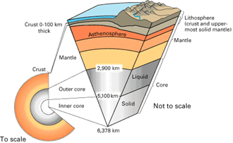
Cutaway
views showing the internal structure of the Earth. Above: This view drawn to
scale demonstrates that the Earth's crust literally is only skin deep. Above
right: A view not drawn to scale to show the Earth's three main layers (crust,
mantle, and core) in more detail (see text).
The Crust
Sediments are loose material such as mud or sand. They tend to settle towards the deep portion of the ocean basins, moving away from the mid ocean ridge and the continental rise. These are known as lithogenous sediments and come from the break down of rock due to erosion and other mechanical processes.
Other sediments are biogenous in origin, or they come from once living organisms. Marine biogenous sediments meet all the characteristics of good farming soil (dark, foul smelling, sticky, high organic content). These sediments are collectively called oozes. There are two types of ooze: Calcareous ooze is high in calcium carbonate (CaCO3) and Siliceous ooze is high in silica (SiO2). Both of these sediment types form from the remains of dead plants and/or animals.
Investigations of thermal activity as it pertains to plate tectonics lead to the discovery of a new type of life in the mid 1980's. Biologists had assumed all life was dependant on the sun. Autotrophs converted the sun's energy into a usable form and these organisms formed the base of the food web. Other organisms called heterotrophs then consumed the producers as energy advanced up the food web.
While studying thermal vents, literally, thin spots in the crust where gases from the mantle escape, biologists discovered a new type of life in the ultra-deep ocean. These chemotrophs (chemical feeding) survived on the sulfides venting from black smokers (chimney-like structures that build up due to chemical deposition). Chemotrophes are bacteria-like organisms that form the base of a food web in waters too deep for sun light to penetrate. Other organisms, mostly marine worms, form the higher levels of the food web.
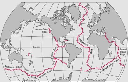
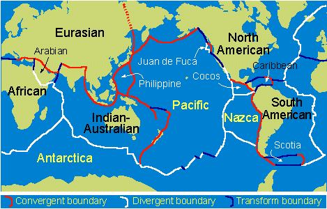
The mid-ocean ridge (shown in red) winds its way between the continents much like the seam on a baseball.
Geologic
Areas of the Ocean
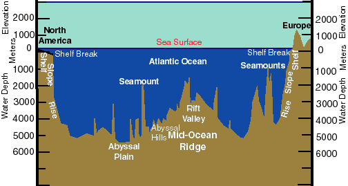
The bottom of the ocean is not smooth like a bathtub. In fact, there is more varied topography on the ocean floor than there is on dry land. The following discussion will trace the start of marine topography on one side of an ocean and follow it through to the other side. The first area one encounters is the ITZ, or inter-tidal zone. This is the area on the beach that is located between the high and low tide marks. This is one of the most biologically diverse areas on earth. Organisms living here must adapt to or withstand very harsh conditions. Within in a 24 hour period, most places will have two high and two low tides. Organisms must cope with being exposed to air for long periods and then being underwater for long periods. They must deal with increased UV radiation as they are exposed to direct sunlight. Increasing salinity and temperature due to evaporation of tidal pools can be deadly. There is also pounding from wave action and increased predation as organisms are exposed.
![]() What Is It Like Below the Surface of the
Earth? (01:17)
What Is It Like Below the Surface of the
Earth? (01:17)
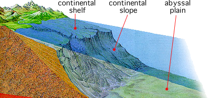
Continental Shelf
In a passive zone, the shelf is very wide (Eastern seaboard of
U.S.). In an active zone, the shelf is very narrow (Western seaboard of U.S.).
This region extends to the shelf break. The shelf break is the point of
transition to the next region. It is generally defined as the point where
declination exceeds two degrees (downward angle of the ground is greater than
two degrees). The shelf break also marks the start of the next region.
The Continental Slope
The slope is a region of rapid decent into the deeper parts of the
ocean. Somewhere along the slope we enter into the aphotic zone.
Aphotic Zone
This is the point where sunlight will no longer penetrate the ocean's waters. In the aphotic zone, we will no longer find living, attached green plants (no sunlight = no photosynthesis). This usually occurs around 200 meters in depth. Eventually the angle of drop on the continental slope begins to lessen. This marks the beginning of the continental rise.
Continental Rise
This is the region that marks the transition from basatic ocean
plate to granitic continental plate. The change in angle also allow for
sediments to settle out from the water that gravity is causing to "flow
downhill" along the continental slope. In a techtonically active zone, the
next region encountered would be a trench - the deepest points on the planet.
After the trench, one would encounter the abyssal plain. In a techtonically passive
zone, the abyssal plain starts where the continental rise ends. The abyssal
plains would equate to the prairies of the dry land. They are large, open areas
with a gently rolling slope. The abyssal plain gives way to abyssal hills.
These equate to dry land foothills and are found in the approximate middle of
the ocean. The abyssal
hills mark the start of the mid-ocean ridge. This is the longest
mountain chain on the planet and branches of this range run through the
Atlantic, Indian, and Pacific Oceans. An individual mountain within the ridge
is called a seamount. A combination of erosion and subduction can cause some
seamounts to become flat topped. These equate to dry land mesas and are called
guyots.
A guyot is usually limited to warmer waters and can have a coral reef surrounding it to form an atoll (circular reef island). Of course, when a seamount sticks up out of the water, it is called an island. This brings us half-way across an ocean. A duplicate, or mirror image, of what has been described will complete the journey to the other side of the ocean.
![]() What Are the Continental Shelf,
Continental Slope, and the Continental Rise?
(01:00)
What Are the Continental Shelf,
Continental Slope, and the Continental Rise?
(01:00)
Historical
Information
Theory dealing with the dynamics of the Earth's outer shell, the lithosphere. According to the theory, the lithosphere consists of about a dozen large plates and several small ones. These plates move relative to each other and interact at their boundaries, where they diverge, converge, or slip relatively harmlessly past one another. Such interactions are thought to be responsible for most of the seismic and volcanic activity of the Earth, although earthquakes and volcanoes are not wholly absent in plate interiors. While moving about, the plates cause mountains to rise where they push together and continents to fracture and oceans to form where they pull apart. The continents, sitting passively on the backs of plates, drift with them and thereby bring about continual changes in the Earth's geography.
![]() What Are the Lithosphere and the
Asthenosphere? (01:17)
What Are the Lithosphere and the
Asthenosphere? (01:17)
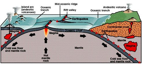
(above) Summary of the seafloor spreading hypothesis.
Young oceanic lithosphere forms at the oceanic ridge system and is consumed at
trenches. Magma rises to the surface at oceanic ridges, increasing heat flow.
Shallow earthquakes are located at ridges and trenches but deep earthquakes
only occur at trenches.
The theory of plate tectonics, formulated during the late 1960s, rests on a broad synthesis of geologic and geophysical data. It is now almost universally accepted and has had a major impact on the development of the Earth sciences. Its adoption represents a true scientific revolution, analogous in its consequences to the Rutherford and Bohr atomic models in physics or the discovery of the genetic code in biology. Incorporating the much older idea of continental drift, the theory of plate tectonics has made the study of the Earth more difficult by doing away with the notion of fixed continents, but it has at the same time provided the means of reconstructing the past geography of continents and oceans. While its impact has, to a considerable degree, run its course in marine geology and shows signs of reaching the limits of usefulness in the study of mountain-building processes, its influence on the scientific understanding of the Earth's history, of ancient oceans and climates, and of the evolution of life is only beginning to be felt.
![]() Plate Tectonics (01:21)
Plate Tectonics (01:21)
![]() How the Inner Structure of Planet Earth
Affects Plate Tectonics (05:43)
How the Inner Structure of Planet Earth
Affects Plate Tectonics (05:43)
Click on the links for a detailed treatment of the various land and submarine relief features associated with plate motion.
 Alfred Lothar Wegener (1880-1930), the
originator of the theory of continental drift. (Photograph courtesy of the
Alfred Wegener Institute for Polar and Marine Research, Bremerhaven, Germany.)
Alfred Lothar Wegener (1880-1930), the
originator of the theory of continental drift. (Photograph courtesy of the
Alfred Wegener Institute for Polar and Marine Research, Bremerhaven, Germany.)
Alfred
Wegener and the Concept of Continental Drift
Wegener was by training and profession a meteorologist (he was highly respected for his work in climatology and paleoclimatology), but he is best remembered for the foray into geology that led to his formulation of the concept of continental drift. In 1910, again because of the geography of the Atlantic coastlines, Wegener came to consider the existence of a single supercontinent during the late Paleozoic era (about 350 to 225 million years ago) and named it Pangaea. He searched the geologic and paleontological literature for evidence attesting to the continuity of geologic features across the Indian and Atlantic oceans, which he assumed had formed during the Mesozoic era (about 245 to 66.4 million years ago). His efforts proved rewarding, and he presented the idea of continental drift and some of the supporting evidence in a lecture in 1912. This was followed in 1915 by his major work, Die Entstehung der Kontinente und Ozeane (The Origin of Continents and Oceans).
The idea of large ancient continents composed of several of the present-day smaller ones had been put forth in the late 19th century by the Austrian geologist Eduard Suess. Suess, however, was not thinking of continental drift. In the spirit of his day, he assumed that portions of a single enormous southern continent—designated Gondwana, or Gondwanaland—foundered to become the Atlantic and Indian oceans. Such sunken lands, along with vanished land bridges, were frequently invoked in the late 1800s to explain sediment sources apparently present in the ocean and to account for floral and faunal connections between continents. They remained popular until the 1950s, stimulated believers in ancient Atlantis, and even made their way into literary works.
Yet, it was already known that the concept of isostasy rendered large sunken continental blocks geophysically impossible, and Wegener characteristically introduced his continental drift proposal by pointing this out. Only then did he proceed to conclude that, if the continents had been once joined together, drift of their fragments rather than their foundering would have been the consequence. The assumption of a former single continent could be tested geologically, and Wegener next displayed a large array of data. Even today his evidence, ranging from the continuity of fold belts across oceans and similarities of sequences of strata on their opposite sides to paleobiogeographic and paleoclimatological arguments, would be judged worthy of serious consideration. He further argued that, if continents could move up and down in the mantle as a result of buoyancy changes produced by, say, erosion or deposition, they should be able to move horizontally as well. The driving forces he considered, however, were unconvincing: both pole fleeing and the westward tidal force appeared to most to be entirely inadequate.
Wegener's proposition was attentively received by many European geologists, and in England Arthur Holmes pointed out that the lack of a driving force was hardly sufficient grounds to scuttle the entire concept. As early as 1929, Holmes proposed an alternative mechanism—namely, convection of the mantle, which remains today a serious candidate for the force driving the plates. Wegener's ideas also were appreciated by geologists in the Southern Hemisphere. One of them, the South African Alexander Du Toit, remained a lifelong believer. After Wegener's death, Du Toit continued to amass further evidence in support of continental drift.
![]() Now answer questions 1 through 10.
Now answer questions 1 through 10.