ROCK
LAYERS AND EARTH MOVEMENT
Unit Overview
This unit explains how folding, faulting and uplifting can rearrange the rock layers, so the youngest is not always found on top.
|
GLOSSARY OF KEY TERMS |
|
axial
plane: An axial plane is a planar
(two-dimensional) surface that connects the hinge lines of the strata in a
fold. It is found by connecting all the places where strata in the fold
change dip direction. |
|
brittle: having little elasticity; hence easily cracked or
fractured or snapped |
|
deposition: The natural process of laying down a deposit of
something. |
|
ductile: workable; material, as metal, able to be stretched or
hammered thin without breaking, something not brittle, easily molded |
|
fault: A fault is a fracture in the continuity of a rock
formation caused by a shifting or dislodging of the earth's crust, in which
adjacent surfaces are displaced relative to one another and parallel to the
plane of fracture. |
|
fault Plane: the plane along which the break or shear of a fault
occurs. |
|
fold axis: an imaginary plane that divides a fault in half. |
|
folding: the bending of layered rock under great pressure and
time. |
|
footwall: the mass of rock beneath a fault. |
|
geologist: a scientist who studies the history of the earth as
recorded in rocks. |
|
geology: a science that deals with the history of the earth as
recorded in rocks |
|
hanging
wall: the block of rock above an
inclined fault surface |
|
Law
of Superposition: The Law of Superposition states
that in a sequence of sedimentary rocks, the lowest layers are the oldest and
the uppermost layers are the youngest as long as there has been no
disturbance of the layers. |
|
limbs: the two upward or downward
parts of a geological fold |
|
relative
age: the age of a rock (older or
younger) in comparison with the age of other rocks |
|
strata: (plural) beds or layers of sedimentary rock having
approximately the same composition throughout |
|
stratigraphy: Stratigraphy is the layering of deposits in
archaeological sites. Cultural remains and natural sediments become buried
over time, forming strata. |
Print out the Key Term Crossword
puzzle with answer key for extra practice:
Digging for Clues
As you have learned in previous units, our Earth is in constant motion and constantly changing. Scientists worldwide are studying these tectonic processes by collecting data on rock types, the location of certain rock types, and how the rocks are layered on top of each other. Scientists who study the Earth's physical make-up are called geologists. When geologists look at this data and compare it to different regions of the Earth, they can verify much about how the land was formed and calculate the age of the rocks. In this unit, you will learn how scientists can tell the relative age of rocks. Relative age determines which rocks are older than the rocks around them by first determining the rocks that were in place.
Scientists look at the stratigraphy of rocks to determine their relative age. Stratigraphy is the layering of rock. The laws of stratigraphy can help scientists understand Earth's past. The laws of stratigraphy are usually credited to a geologist from Denmark named Nicolas Steno. He lived in the 1600s. The laws are illustrated in the Figure below. Refer to the Figure as you read about the laws.
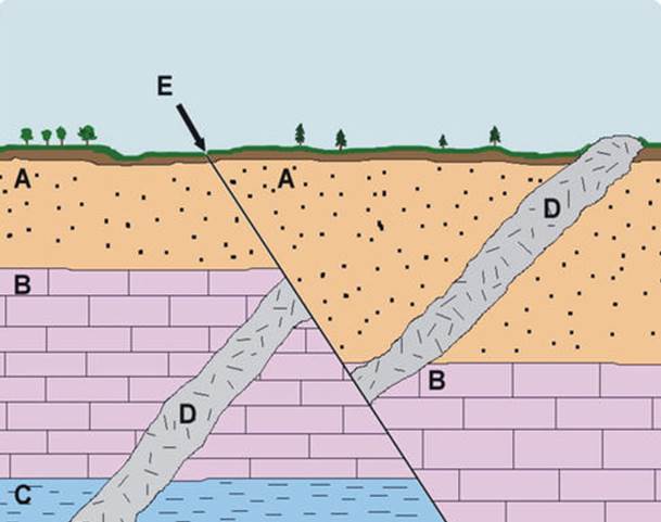
Laws of Stratigraphy. This diagram illustrates the laws of
stratigraphy. A = Law of Superposition, B = Law of Lateral Continuity, C = Law of
Original Horizontality, D = Law of Cross-Cutting Relationships
A.
Law of Superposition
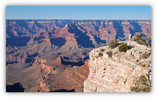
Superposition refers to the position of rock layers and their relative ages. Relative age means age compared to other rocks, either younger or older. The relative ages of rocks are essential for understanding Earth's history. New rock layers are always deposited on top of existing rock layers. Therefore, deeper layers must be older than layers closer to the surface. This is the law of superposition. You can see an example in the Figure below.
Superposition. The rock layers at the bottom of this cliff are much
older than those at the top
B.
Law of Lateral Continuity
Rock layers extend laterally or out to the sides. They may cover extensive areas, primarily if formed at the bottom of ancient seas. Erosion may have worn away some of the rock, but layers on either side of eroded areas will still "match up."
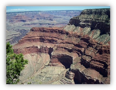
Look at the Grand Canyon in the Figure below. It's an excellent example of lateral continuity. You can see the same rock layers on opposite sides of the canyon. The matching rock layers were deposited simultaneously, so they are the same age.
Lateral
Continuity. Layers of the same rock type are found across canyons at the Grand
Canyon.
C. Law of Original Horizontality
Sediments were deposited in ancient seas in horizontal or flat layers. If sedimentary rock layers are tilted, they must have moved after they were deposited.
D. Law of Cross-Cutting Relationships
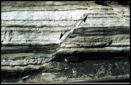
Rock layers may have another rock cutting across them, like the igneous rock in the Figure below. Which rock is older? To determine this, we use the law of cross-cutting relationships. The cut rock layers are older than the rock that cuts across them.
How
do scientists tell the age of the rocks if the layers are disturbed?
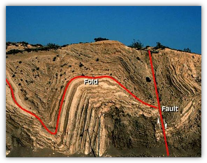
To study how rocks are layered naturally, looking at the Earth's processes that can move and displace rock is essential. The first process we will look at is folding. Folding happens when significant pressure is applied to rocks over time. If the material that the rock is formed from is ductile, then the rock will bend rather than crack or break. Look at the picture below. The fold in the rock wall below shows how the rock layer was bent into a curved shape.
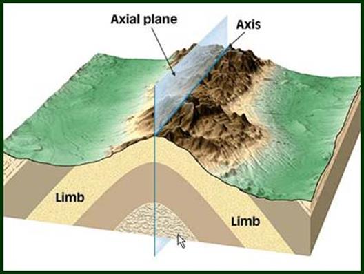
Folds are formed during mountain-building processes. The flat layers of sedimentary rock or volcanic rock are under tremendous pressure and eventually are moved into structures that look like waves. They can bend upwards or downwards.
A fold has three major parts: (see Figure below)
1. limbs: the two sides of the fold
2. fold axis: a line drawn along the points of the maximum curve of each layer
3. axial plane: an imaginary surface that divides a fold in half
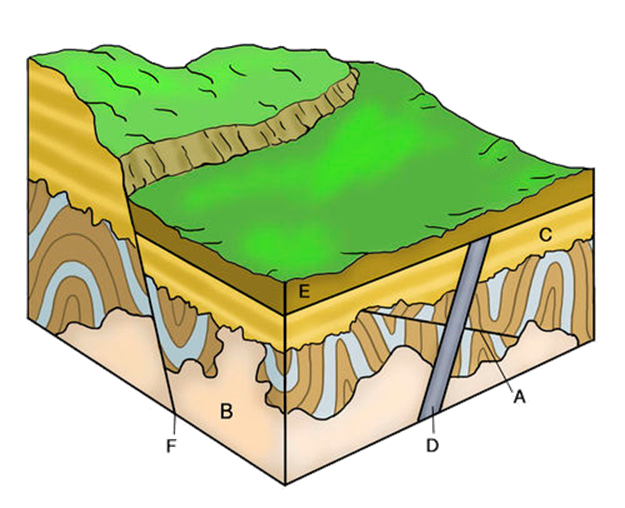
Another deformation in a rock layer is the fault. Faults are cracks in a rock layer where there has been movement between the two halves of the rock layer. Part of the rock wall will be above the fault plane (the line or crack in the wall) and is called the hanging wall. Part of the wall will be below the fault plane and is called the footwall. Faults usually occur in brittle rock material. There are three main types of faults.
Normal faults: where the hanging wall falls below the footwall. Here is a sample:
In the picture above, the fault plane is the crack going down the rock wall. The hanging wall is on the left of the fault plane, and the footwall is on the right of the fault plane. Look for the black arrows near the fault plane. As you can see, they show how the hanging wall has slipped lower than the footwall, making this a normal fault.
Reverse fault: (dip-slip fault) the hanging wall moves up relative to the footwall. Here is a sample:
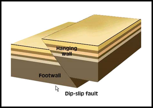
In the picture above, you can see that the hanging wall is above the footwall.
In a Strike-slip fault, the two sides of the rock wall slide past each other. This is the same type of movement as the transform fault boundary. Look at the sample below:
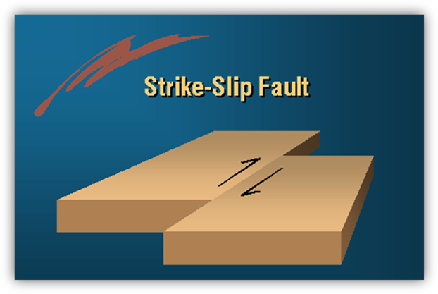
As you can see in the picture, both sides of the wall remain at the same elevation but are moving in opposite directions.
How do scientists determine the age of rock if a fault or fold has occurred in rock layers? When looking at a fault, they need to see how far the fault plane travels and what type of fault it is, and then they can determine which layers are the oldest. Look at the figures below for an example of a normal and reverse fault.

Other normal processes can occur with rock layers, such as erosion. Wind, water, or chemicals can wear away parts of rock layers over many years. Then new rock layers are deposited above the eroded, folded, and faulted layers. It is then possible to get rock strata like the pictures below.
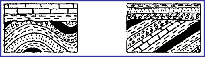
All the patterns above represent different types of rock in each layer.
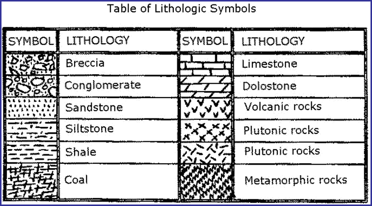
As you can see from the pictures above, the chart has many different patterns. Each pattern represents a different type of rock. Geologists use a key to help them draw and read their strata charts. The chart below shows a geologist's key for drawing strata maps. Look at the key and then see if you can name some rock types in the two pictures above. Keep track of how you are doing by writing down your answers.
Geology is the study of the Earth's history as recorded in rocks. This science helps us understand the physical make-up of our Earth and how it is changing daily. The data scientists collect vital to understanding our future and past. The processes that happened thousands of years ago are still changing our Earth today. The next time you have the opportunity to see a large rock wall, look at its stratigraphy. Mountains along roads and highways are good places to look since many have been cut away so the road could be built. Can you tell which rock layers are the youngest? Can you determine if there have been disturbances in the rock layers and what type of disturbance has occurred? Maybe you can even draw your chart using the symbols above to represent rock, or you can make up your key. Learn to use your powers of observation and the information you have learned from this unit to investigate the geology around your home and your community.