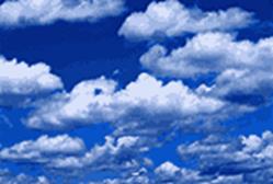
![j0205434[1]](SCI170U29Weather_Formations_image003.png)
WEATHER
PREDICTIONS AND CLOUD FORMATIONS
Unit Overview
In this unit you will learn
of the relationship between cloud types and weather forecasting. Clouds give us clues about what is going on
in the atmosphere and how the weather might change the hours or the days to
come. Each type of cloud forms in a
different way, and each generates its own kind of weather.
Unit Directions
Read the text carefully and
intently, study the visuals, and answer the questions that follow at the
conclusion of this unit.
Introduction
Clouds are water. As you know from previous units, water is found in three forms: liquid, solid and gas. Water in the gaseous form is called water vapor. Warm air can hold more moisture than cold air. As warm, moist air rises in the atmosphere, its temperature begins to drop. Because cold air cannot hold as much water vapor as warm air, the rising air soon becomes saturated. At this point, the water vapor in the air begins to condense, or change into a liquid. The temperature at which water vapor condenses is called the dew point. Clouds form when water vapor turns back into liquid water droplets. It happens in one of two ways: when the air cools enough, or when enough water vapor is added to the air. You’ve seen the first process happen on a summer day as drops of water gather on the outside of a glass of ice tea. That’s because the cold glass cools the air near it, causing the water vapor in the air to condense into liquid. Unlike the drops on the side of your glass though, the droplets of water in a cloud are so small that it takes about one million of them to form a single raindrop. While most clouds form this way, cooling comes not from ice in a glass but as the air rises and cools high in the sky. Each tiny cloud droplet is light enough to float in the air, just as a little cloud of vapor floats out from your breath on a cold day.
Air has to be just a little
bit dirty for clouds to form because water vapor needs a surface on which to
condense. Fortunately, even the cleanest
air has some microscopic particles of dust, smoke, or salt for water droplets
to cling to, so the air is rarely too clean for clouds to form.
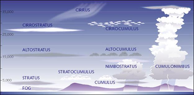
CLASSIFICATIONS OF CLOUDS
A cloud is a visible
collection of very fine water droplets or ice crystals suspended in the
atmosphere at altitudes from just above the ground to several miles above sea
level. As you can see for yourself just from looking at the sky, clouds come in
all sorts of shapes and sizes. Meteorologists
name clouds by how high in the sky
they form and by their appearance.
Most clouds have two parts to their name.
Usually the first part of the name has to do with the height and the second part refers to
the appearance.
Cloud Heights
High
clouds
If
clouds form at the highest levels, they get the prefix “cirr-”
as the first part of their name. In Latin, cirrus means “curl of hair.”
Sometimes cirrus clouds are also called mares’ tails.
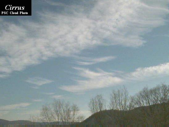
 Cirrus
 High cirrus cloud forms include detached clouds of delicate
and fibrous appearance, generally white in color, often resembling tufts or
featherlike plumes, and composed entirely of ice crystals; cirrocumulus (mackerel sky) clouds
are composed of small white flakes or very small globular masses, arranged in
groups, lines, or ripples; and cirrostratus
clouds are a thin whitish veil, sometimes giving the entire sky a milky
appearance, which does not blur the outline of the sun or moon but frequently
produces a halo.
High cirrus cloud forms include detached clouds of delicate
and fibrous appearance, generally white in color, often resembling tufts or
featherlike plumes, and composed entirely of ice crystals; cirrocumulus (mackerel sky) clouds
are composed of small white flakes or very small globular masses, arranged in
groups, lines, or ripples; and cirrostratus
clouds are a thin whitish veil, sometimes giving the entire sky a milky
appearance, which does not blur the outline of the sun or moon but frequently
produces a halo.
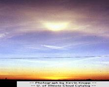
High-level
clouds form above 20,000 feet and since the temperatures are so cold at such
high elevations, these clouds are primarily composed of ice crystals. Cirrus clouds, which are a sign of warm
moist air rising up over cold air, are sometimes an early signal that
thickening clouds could bring light rain or snow within one or two days.
Although
high-level clouds are typically thin and white in appearance like wisps of
white hair, they can appear in a magnificent array of colors when the sun is
low on the horizon. (Refer below to a photo.)
High Level Clouds
|
High Clouds (18,000 feet and above) |
||
|
|
|
|
|
CIRRUS clouds are white,
ice crystal clouds, wispy in appearance. They may take on the appearance of a
mare’s tail because as ice crystals fall from the cloud they often encounter
changing winds and so "tail" off. |
CIRROSTRATUS clouds are a
thin veil of ice crystals usually covering most or all of the sky. A
"halo" may appear around the sun or moon due to refraction (or
bending) or light rays in the ice crystals; cirrostratus clouds are often a
sign of approaching storms. |
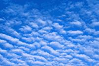
CIRROCUMULUS clouds are
milky-white with a dappled or wave-like appearance. During the day,
refraction of the sun’s rays may cause one or more "mock-suns" to
appear on either side of the sun. |

Middle Clouds
 Middle clouds get the prefix “alto.” Intermediate
clouds include altocumulus, patchy layer of flattened globular masses arranged in
groups, lines, or waves, with individual clouds sometimes so close together
that their edges join; and altostratus, resembling thick cirrostratus without
halo phenomena, like a gray veil, through which the sun or the moon shows
vaguely or is sometimes completely hidden.
Middle clouds get the prefix “alto.” Intermediate
clouds include altocumulus, patchy layer of flattened globular masses arranged in
groups, lines, or waves, with individual clouds sometimes so close together
that their edges join; and altostratus, resembling thick cirrostratus without
halo phenomena, like a gray veil, through which the sun or the moon shows
vaguely or is sometimes completely hidden.
The bases of mid-level clouds
typically appear between 6,500 to 20,000 feet. Because of their lower
altitudes, they are composed primarily of water droplets; however, they can
also be composed of ice crystals when temperatures are cold enough. Refer below
to a photo of mid-level clouds.
|
Middle Clouds (7000-18000 Feet) |
||
|
|
|
|
|
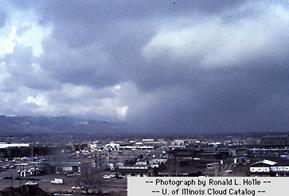
ALTOSTRATUS clouds are gray or blue-gray clouds composed of water droplets or a mix of water droplets and ice crystals. Sun may be dimly visible as through ground glass. Altostratus clouds are often a sign of approaching rain or snow. |
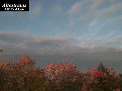
Altostratus
clouds form a bluish or grayish
veil that totally or partially covers the sky. The sun can barely be seen
through altostratus and its edges are not distinct. Altostratus clouds are
water or ice clouds, and they do not produce halos. Altostratus is classified
as a middle cloud. Featureless altostratus clouds are thin
enough (translucent) to show the sun in the late afternoon, on 6 December
1989 at Boulder, Colorado, USA. Note that the sun has blurry edges. ( Photo ©
1989 Ronald L. Holle.) |
ALTOCUMULUS clouds are patchy with a wave-like or dappled appearance. They are distinguished from Cirrocumulus by the color which is gray or blue gray (Cirrocumulus is milky-white); sometimes they are referred to as a "Mackerel sky.” Altocumulus clouds take many forms. They can look like waves on the sea, tiny cumulus, balls of cotton, or even little castle towers. The individual "cloudlets" are usually between one and two fingers wide at arm's length. They are thick enough to have gray bases. Altocumulus clouds are almost always made up of water droplets, but sometimes contain ice crystals as well. The tiny water droplets in altocumulus can produce rainbow-like colors. Most commonly, this is in the form of rainbow-colored circles around the sun or moon. This is called an "aureole.” An aureole is commonly around the width of a fist, held at arm's length. Altocumulus is classified as a middle cloud. |

Low Clouds
 Low clouds don’t get a prefix.They
are mostly composed of water droplets since their bases generally lie below
6,500 feet. Low clouds include stratocumulus, a cloud layer or patches composed
of fairly large globular masses or flakes, soft and gray with darker parts,
arranged in groups, lines, or rolls, often with the rolls so close together
that their edges join; stratus, a uniform layer resembling fog but not resting
on the ground; and nimbostratus, a nearly uniform, dark grey layer, amorphous
in character and usually producing continuous rain or snow. However, when
temperatures are cold enough, these clouds may also contain ice particles and
snow. Refer below to a photo of low-level clouds.
Low clouds don’t get a prefix.They
are mostly composed of water droplets since their bases generally lie below
6,500 feet. Low clouds include stratocumulus, a cloud layer or patches composed
of fairly large globular masses or flakes, soft and gray with darker parts,
arranged in groups, lines, or rolls, often with the rolls so close together
that their edges join; stratus, a uniform layer resembling fog but not resting
on the ground; and nimbostratus, a nearly uniform, dark grey layer, amorphous
in character and usually producing continuous rain or snow. However, when
temperatures are cold enough, these clouds may also contain ice particles and
snow. Refer below to a photo of low-level clouds.
Cloud Appearance
There are two cloud appearance types: cumulus and stratus, which are also the basic names of the low clouds. Sometimes they appear higher in the
atmosphere and get a combination name with a prefix. For example, middle cumulus clouds are called
“altocumulus” and high stratus clouds are “cirrostratus.” If a cloud produces rain or snow it gets
either “nimbo”
at the beginning or “nimbus” at the end. In Latin, nimbus means rain cloud.
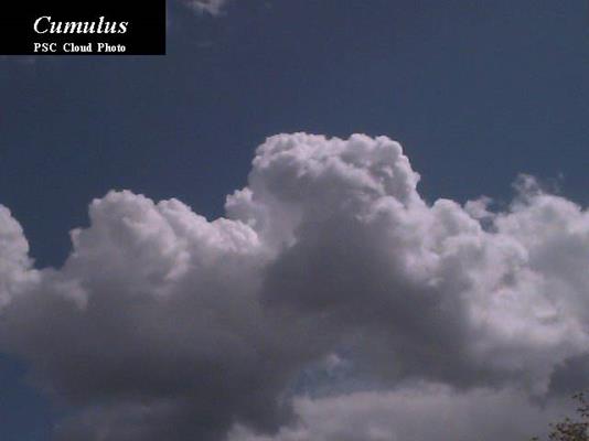
Cumulus Clouds
 Cumulus clouds are low individual billowy globs that
are low, have flat bases and look a little like cauliflower. In Latin, cumulus
means "heap." Cumulus clouds look like a heap of cotton balls
or whipped cream. They are at least as tall as they are wide and form on sunny
days from pockets of rising air. Their
constantly changing outlines are fun to watch because they can take the shapes
of almost anything, including animals and faces. Cumulus clouds often have a horizontal base
and a dome-shaped upper surface that frequently resembles a head of cauliflower
and shows strong contrasts of light and shadow when the sun illuminates it from
the side. Cumulus clouds usually signal fair weather.
Cumulus clouds are low individual billowy globs that
are low, have flat bases and look a little like cauliflower. In Latin, cumulus
means "heap." Cumulus clouds look like a heap of cotton balls
or whipped cream. They are at least as tall as they are wide and form on sunny
days from pockets of rising air. Their
constantly changing outlines are fun to watch because they can take the shapes
of almost anything, including animals and faces. Cumulus clouds often have a horizontal base
and a dome-shaped upper surface that frequently resembles a head of cauliflower
and shows strong contrasts of light and shadow when the sun illuminates it from
the side. Cumulus clouds usually signal fair weather.
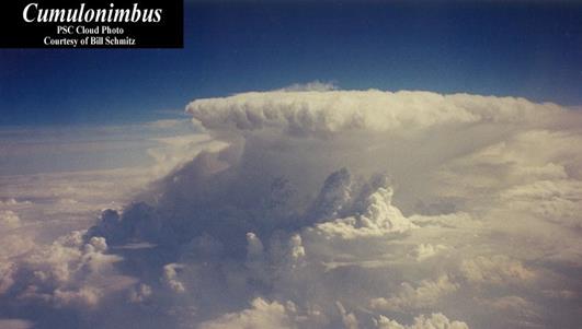
However, when cumulus clouds
build into the middle or high part of the atmosphere and get larger and darker
on the bottom, they  get the name cumulonimbus, a thunderstorm cloud with heavy masses of great vertical
development whose summits rise in the form of mountains or towers. The upper
parts have a fibrous texture, often spreading out in the shape of an anvil, and
sometimes reaching the stratosphere.
Cumulonimbus clouds are tall, deep, and dark and can bring
showers of rain, snow, or thunderstorms, lightning, heavy rain and even severe
weather such as hail, damaging winds or tornadoes. They are a sign of rapidly rising and sinking
air currents.
get the name cumulonimbus, a thunderstorm cloud with heavy masses of great vertical
development whose summits rise in the form of mountains or towers. The upper
parts have a fibrous texture, often spreading out in the shape of an anvil, and
sometimes reaching the stratosphere.
Cumulonimbus clouds are tall, deep, and dark and can bring
showers of rain, snow, or thunderstorms, lightning, heavy rain and even severe
weather such as hail, damaging winds or tornadoes. They are a sign of rapidly rising and sinking
air currents.
Stratus Clouds
 Stratus clouds are layered and cover most of the sky. In Latin, stratus means "covering"
or "blanket." Stratus clouds look like a flat blanket in the
sky. They are much wider than they are tall.
Stratus clouds are layered and cover most of the sky. In Latin, stratus means "covering"
or "blanket." Stratus clouds look like a flat blanket in the
sky. They are much wider than they are tall.
|
|
|
|
|
|
Stratus clouds are usually gray seen from below, fairly uniform horizontally, and lie close to the surface of the Earth. They usually look like a solid layer but are sometimes found in patches. Stratus clouds can produce light precipitation. They are usually water clouds. When the sun is visible through stratus clouds, its edges are distinct. Stratus is classified as a low cloud. |
If you see stratus clouds in broken or puffy layers, they
are stratocumulus clouds. |
If you see stratus clouds in thin high
layers that turn the sky solid white, they're cirrostratus clouds. Cirrostratus clouds are a thin, transparent, whitish layer made up of ice crystals. They may partially or totally cover the sky. Tiny prisms of ice in a cirrostratus layer can bend the sun's light. As a result, often you can see a halo or veil of rainbow colors around the sun. These patches of rainbow-colored light are sometimes called "sundogs" and occur on the halo on both sides of the sun. Cirrostratus is classified as a high cloud. |
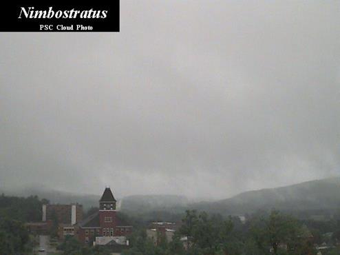
When stratus clouds are very thick, they become dark nimbostratus clouds that can produce rain, drizzle or snow Nimbostratus clouds are usually gray, and you cannot see the sun through them. They are associated with continuous precipitation that often makes the bottom of the cloud hard to see. Sometimes it is difficult to tell a nimbostratus cloud from a cumulonimbus cloud. However, if there is lightning and thunder, the cloud is probably cumulonimbus. Also, showery (intermittent) precipitation is associated with cumulonimbus. Nimbostratus clouds from photographs can often be mistaken for stratocumulus or stratus clouds, and vice versa, because it is often difficult to judge whether or not rain is present from a photograph. Nimbostratus is classified as a low cloud, but it can also be classified as a middle cloud. When stratus clouds form close to the ground, the result is fog. |


LOW CLOUDS (below 7000 feet)
|
|
|
|
STRATUS clouds are low, gray, flat water droplet clouds (called fog if they touch the ground) with no clear structure. Drizzle may occur from these clouds. |
|

|
|
|
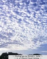
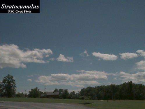
STRATOCUMULUS clouds are low layered clouds with some observed structure and varying color. Often stratocumulus clouds are the result of both mixing and low-level instability. They are a sign of blustery and relatively cool conditions with possible showers or rain or snow. |
|
|
|
|
CUMULUS clouds are small heaped clouds with flat bottoms and rounded tops and most commonly seen in an otherwise blue sky. They are usually a sign of fair weather and thus often referred to as Fair Weather Cumulus. |
|
Summary of Cloud
Classifications
FRONTS
Fronts are boundaries between
two air masses of different temperatures. Fronts are actually zones of
transition, but sometimes the transition zone, called a frontal zone, can be
quite sharp. The type of front depends on both the direction in which the air
mass is moving and the characteristics of the air mass. The four types of
fronts discussed in this unit include: cold
front, warm front, stationary front, and occluded front.
The frontal zone represents
the leading edge of a wedge of cold/cool air. If the wedge is moving into an
area of warmer air, the front is called a cold front. If the wedge is
retreating and warmer air is moving into an area previously occupied by cool
air, the front is termed a warm front.
Warm Fronts
A warm front is a surface
along which advancing warm air displaces cold air. A warm front is slower than
a cold front. Although they can trigger thunderstorms, warm fronts are more
likely to be associated with large regions of gentle ascent (stratiform clouds and light to moderate continuous rain).
Warm fronts are usually preceded by cirrus first (1000 km ahead), then
altostratus or altocumulus (500 km ahead), and finally stratus and possibly
fog. Behind the warm front, skies are relatively clear but change gradually.
In a warm front, the warm air
is ramped up and over the colder, denser air. The warm air is cooled and so
clouds and precipitation may develop.
|
|
|
Side View of a Typical Warm Front |
Warm
fronts are nearly always well defined by tropical
stratified clouds. They are generally cirrus,
cirrostratus, altostratus,
nimbostratus, and stratus with the cirrus
appearing as much as 1,000 miles before the
actual surface passage. The cloud types
that form
after passage of the warm front are
typical of the warm air mass.
The precipitation area of
warm fronts extends about 300
miles in advance of the surface
front. Precipitation occurs mainly in
the form of
continuous or intermittent rain, snow, or
drizzle. However, when the warm air is
connectively unstable, showers and thunderstorms
may occur in
addition to the steady precipitation. Abrupt temperature changes, like those characteristic
of cold fronts, do not accompany the
warm frontal
passage. Instead, the temperature change is gradual.
It starts increasing
slowly with the approach of
the front and increases slightly more rapidly with the
passage. The dew point is normally
observed to rise as the front approaches, and a
further increase follows the frontal
passage when the
air in the warm sector is of maritime
origin.
Cold Fronts
A cold front is a surface
along which advancing cold air is displacing warm air. Cold fronts tend to move
faster than other types of fronts and also tend to be associated with the most
violent weather. The cold air wedges beneath
the warm air, lifting it to the surface and often producing frontal clouds and
precipitation.
|
|
|
Side
View of a Typical Cold Front |
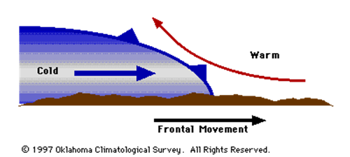
Cold fronts tend to be
associated with cirrus clouds well ahead of the front, strong thunderstorms
along and ahead of the front, and broad areas of clouds immediately behind the
front.
In advance of cold
fronts, the reason the clouds are cumulus is because air is being rapidly
raised to its condensation level. Cumulus clouds are typical of
warm air, but also a sign of unstable air. Towering cumulus,
cumulonimbus, stratocumulus, and nimbostratus are associated with the passage
of a cold front. After passage, these cloud forms
may prevail for several hundred miles with the
slow-moving cold front. Very rapid clearing conditions are
associated with the fast-moving cold front after passage. Well back in
the cold air in both types of cold fronts,
the only clouds normally found are fair-weather
cumulus.
Cold fronts usually bring
cooler weather, clearing skies, and a sharp change in wind direction.
Showers and sometimes thunderstorms occur as a cold front passes.
Continuous precipitation is observed for some
hours after passage of a slow-moving cold
front. Showers and thunderstorm activity of short
duration will occur with the passage of a
fast-moving cold front, followed by very rapid
clearing conditions. Cold fronts usually bring cooler weather,
clearing skies, and a sharp change in wind direction.
Stationary Fronts
Stationary fronts are fronts
that do not move or barely move. Stationary fronts, behave like warm fronts,
but are more quiescent. Warm air is continuously lifted up the frontal surface
which results in cloudiness and precipitation, possibly even extended periods
of precipitation. Many times the winds on both sides of a stationary front are
parallel to the front. Typically stationary fronts form when polar air masses
are modified significantly so as to lose their character (e.g., cold fronts
which stall). Stationary fronts eventually weaken and dissipate.
Occluded Fronts
Occluded fronts are formed
when three rather than two air masses meet. Because cold fronts move faster
than warm fronts, on occasion a cold front can catch up to and overtake their
related warm front. When they do, an occluded front is formed.
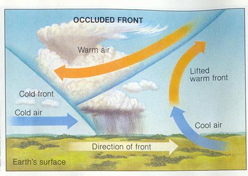
Occluded fronts are
indicative of mature storm systems (i.e., those about to dissipate). The most
common type of occlusion in North America is called a cold-front occlusion and
it occurs when the cold front forces itself under the warm front. The weather
ahead of the cold occlusion is similar to that of a warm front while that along
and behind the cold occlusion is similar to that of a cold front.
|
|
|
Development of an Occluded Front |
Because the
occlusion is a combination of a cold
front and a warm front, the resulting
weather is a combination of conditions that
exists with both. Ahead of a cold-type occlusion,
as the warm air is lifted, all clouds
associated with a warm front are found
producing typical prefrontal precipitation extensively
for a distance of 250 to 300 miles.
Typical cold front weather is found throughout
the narrow belt in the vicinity of the
surface front. However, the thunderstorms are
less intense than those of a typical cold
front. This occurs because the source of
warm air has been cut off from the
surface, and the energy received comes only from
the warm air trapped aloft. Instability showers often
follow the cold front when the cold air is unstable. The most violent
weather occurs on the upper front for
a distance of 50 to 100 miles north
of the northern tip of the warm
sector.
After the occlusion has
passed, the weather usually clears rapidly. The weather associated with
the warm occlusion is very similar to
that of the cold occlusion. With the
warm occlusion, the high-level thunderstorms
associated with the upper cold front develop
quite some distance ahead of the surface
front (up to 200 miles), and the
weather band, in general, is wider (up to
400 miles). The air behind the cold
front, flowing up the warm frontal surface,
causes cumuliform-type clouds to form. In this
area, precipitation and severe icing may be found. The most violent
weather occurs on the upper front, 50 to 100 miles north of the northern tip of
the warm sector.
Predicting Weather
If you study clouds carefully and observe how they
change with the weather, you will see some very consistent patterns. Before
radio, television or newspaper forecasts were readily available, people whose
livelihoods depended on the weather (like sailors or farmers) often used the
clouds as a indicator of what might happen.
Low pressure weather systems especially have a
prescribed sequence of clouds. After a spell of clear weather, usually the
first signs of a change coming are high wispy cirrus clouds. If you check you barometer, it is probably high and
about ready to fall.
These high clouds often thicken and may fill the sky.
When they do, they are called cirrostratus.
Cirrostratus is a white milky ice-crystal cloud. A halo may appear around the
sun or moon with cirrostratus clouds. Usually precipitation is 12 to 24 hours
away when the sky becomes completely covered by cirrostratus.
The clouds often then continue to lower and thicken. Altostratus or middle layer clouds are
often next. They are gray or bluish gray in color. The sun often is still dimly
visible through altostratus clouds but gradually fades. Precipitation is often
just hours away. Winds freshen from the east or southeast.
When rain or snow begins, the clouds are nimbostratus (Remember: nimbus means
rain). Precipitation is usually steady and light to moderate.
Sometimes, especially in spring, heavy downpours and
thunder may signify some imbedded cumulonimbus
in the nimbostratus clouds.
Clouds continue to lower
during the precipitation. When the air becomes saturated near the ground, fog
may form. This is usually a sign you are near a warm front. If the
precipitation ends, winds shift to the south or southwest and the skies
brighten; the warm front is likely to have passed. The air in the warm sector
of storms is usually hazy, unseasonably warm and humid.
Darkening skies and freshening winds are usually the
signs that the next change associated with a storm passage, the cold front is
approaching. Cumulonimbus clouds
(refer to photo above) often precede or accompany the cold front and bring
showers and thunderstorms.
If you tap your barometer, you should see pressures
now near its lowest point. A gusty wind shift to the northwest usually
signifies the passage of the cold front. Typically, the pressure begins to rise
rapidly while temperature and humidity drop and skies partially clear.
Cumulus clouds often follow generally signifying fair
weather.
If the air is cold and winds are strong and gusty,
cumulus clouds may fill the sky during the day. These are called stratocumulus.
Sprinkles or flurries can fall from these clouds if
the air is sufficiently unstable and moist. Eventually winds diminish, the
pressure rises slowly, and blue skies dominate, signifying high pressure is
approaching.
After a day or so of fine weather, cirrus clouds may appear signifying the
approach of the next weather system.

Closing Thoughts
Weather is a part of your
life everyday, whether you are home, sitting in a classroom, on vacation with
your family, or spending time with friends. Certainly weather has an impact. Is
the sun shining? Are there clouds in the sky? Is rain on the way? After
completing this unit and becoming familiar with cloud formations and their impact
on weather, you can begin making your own weather predictions.