PLATE
TECTONICS: THE UNIFYING THEORY
Unit Overview
This unit introduces the theory of
plate tectonics. Our Earth is described as a changing, evolving planet with a
very active interior structure. Scientific experimentation and research shows
that the Earth’s landmasses are moving. Scientists believe that the internal
structure of the Earth and the heating of the layers are responsible for this
movement.
|
GLOSSARY
OF KEY TERMS |
|||
|
crust |
mantle |
core |
magma |
|
continental drift |
plate tectonics |
lithosphere |
subduction |
|
tectonic plates |
subduction zone |
plate boundaries |
|
Crater Lake, Oregon
Look at the picture of the beautiful
lake below. You can tell by its name that it is a crater of some sort, but what
created that crater? Look at the other pictures of the lake below.
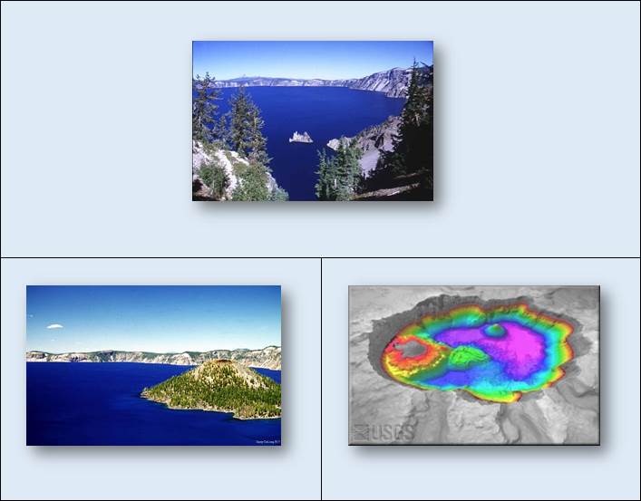
The picture on the left shows a
volcanic cone jutting out of Crater Lake. The crater was created by an ancient
volcano named Mount Mazama. The mountain erupted approximately 6900 years ago
and then collapsed into a huge crater that eventually filled with water and
melted snow. The volcanic cone was created by a second eruption many years
later. The picture on the right was taken in an attempt to map the floor of
Crater Lake in order for scientists to gather information on the volcano and
the activity that has taken place on the floor of the lake over the centuries.
This picture was taken with the latest multi-beam, side-scan sonar technology.
This information helps scientists understand the movement of the Earth’s crust and the creation of the many
landforms that appear after events such as volcanic eruptions.
In much the same way that geographic borders have
separated, collided, and been redrawn throughout human history, tectonic plate
boundaries have diverged, converged, and reshaped the Earth throughout its
geologic history. Today, science has shown that the surface of the Earth is in
a constant state of change. We are able to observe and measure mountains rising
and eroding, oceans expanding and shrinking, volcanoes erupting and earthquakes
striking.
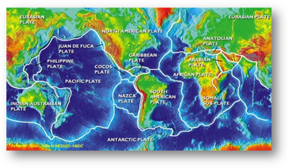
Plate Tectonics
Tharp-Heezen Map of the Ocean Floor
Before the Tharp-Heezen map of the
seafloor was published in 1977, scientists had little understanding of the
geological features that characterized the seafloor, especially on a global
scale. The data and observations represented by the Tharp-Heezen map became
crucial factors in the acceptance of the theories of plate tectonics and
continental drift. The theory of plate tectonics states that the Earth’s solid
outer crust, the lithosphere, is separated into plates that move over the
asthenosphere, the molten upper portion of the mantle. Oceanic and continental
plates come together, spread apart, and interact at boundaries all over the
planet.
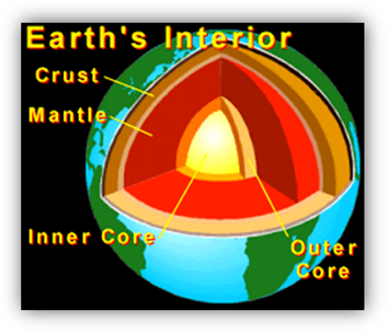
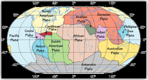
A cross section of the earth reveals
a crust with a complex pattern of interlocked and interactive plates. These
plates derive their name from the predominant continental or oceanic
environment that they underlay. These plates make up the earth's crust. In
total there are seven major plates and a further six large regional plates. In
reality, there are many other complex fault zones and micro-plate boundaries
that are active and as a result produce geological events. Below the crust is
2900 kilometers of mantle. Finally, deeper within the Earth's structure is the
core which is distinguished by two distinct sections; a liquid outer core and a
solid crystal inner core.
The Crust
The crust is the outermost layer of
the earth. It is composed of a mixture of silicate-rich igneous rocks. In
addition there are some metamorphic and sedimentary rocks. Oceanic crust is thinner
in comparison to continental crust (about 8 kilometers thick) compared to 20-70
kilometers) and forms at divergent boundaries.
Oceanic crust is made up of primarily of igneous rocks: Gabbro intrusive rocks in the lower 6km and
extrusive pillow basalt in the upper 2km.
Locally, the crust is metamorphosed by high-temperature fluids. Continental crust is a mixture of igneous,
metamorphic, and sedimentary rocks that is highly variable in age and
composition.
The Mantle
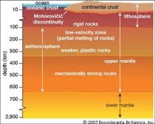
The
mantle below the crust makes up over 80% of the earth's volume. It extends from
the base of the crust to the outer core and is approximately 2800 kilometers in
depth. The mantle consists of igneous low-silicate content rock, rich in iron
and magnesium. The chemical composition of the mantle remains relatively
constant throughout, but it is so thick that it is subjected to a wide range of
temperature and pressure. These differences have helped establish a classification
within the mantle. In general terms we can distinguish the upper and the lower
mantle. As depth increases, the physical properties of the mantle change, and
so does its behavior. It goes from rigid in the uppermost mantle (down to 100
km) to plastic and partially molten (only a very small percentage is actually
molten) in the upper part of the lower mantle and back to being fairly rigid
(but still plastic) in the lower mantle.
Two further zones should be stated. The very upper section of the mantle is
known as the lithosphere but this also includes the crust. Below the
lithosphere and extending to the margin of the lower mantle is the
asthenosphere.
The Core
The
core is primarily a mixture of iron and nickel metals, with a little sulfur.
The inner core is a crystalline solid with this composition, whereas the outer
core is a liquid. The core is approximately 3490 kilometers in
depth. Scientists have been able to distinguish between the outer core and
the inner core through their use of earthquake data regarding the velocity of
seismic waves. Through variations in velocity and refraction of seismic waves,
scientists have been able to map out the various changes within the earth's
structure including the very existence of the inner and outer core.
The highest mountain range above sea level,
the Himalayas, was formed 55 million years ago when the Eurasian and
Indo-Australian continental plates converged.

The Himalayas
The
Mediterranean island of Cyprus formed at a convergent boundary between the
African and Eurasian plates. Hardened mounds of lava, called pillow lavas, were
once on the bottom of the ocean where this convergence occurred, but have been
pushed up and are now visible at the surface.

The Mediterranean
island of Cyprus
Movement in the Mantle
Because the mantle is very hot, most
of the rock is molten. The molten rock is called magma. The heat
energy in this fluid causes convection currents. A convection current is the flow
of a fluid due to heated expansion followed by cooling and contraction. The
magma in the inner mantle gets hot and begins to rise. As the magma moves
toward the outer mantle, it cools and then moves back down. The movement of the
magma against the crust causes movement in the crust.
As early scientists studied the
shape of continents and seismic activities, many theories about the Earth’s
movement and make-up emerged.
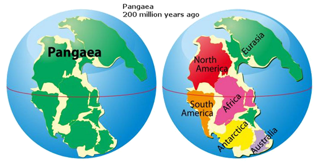
A German scientist named Alfred
Wegener noticed that the coast lines of many continents could fit together like
puzzle pieces.
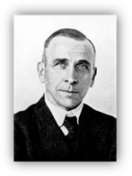
Wegener put the pieces together to create a map that joined all the continents,
forming a supercontinent that he named Pangaea. Wegener used remains of many
organisms to support his theory. He stated that the remains of the same type of
organism were found in continents that are now hundreds of miles apart. He said
this could only happen if the continents were connected at some point in time.
His theory was not widely accepted until scientists discovered evidence on the
ocean floor supporting movements of the continents. This movement is now called
continental drift.
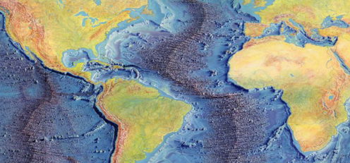
This
theory and the ocean floor discoveries brought about the theory of Plate
Tectonics. The map below shows Pangaea and demonstrates Wegener’s view
of how the continents fit together.
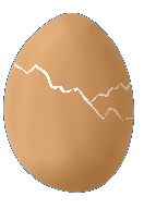
Activity
Take a hard-boiled egg and crack its
shell. Does the egg remind you of anything? The Earth, perhaps? The egg could
be seen as a tiny model of the Earth. The thin shell represents the Earth's
crust, divided into plates; within the shell is the firm but slippery mantle.
Move the pieces of shell around. Notice how the shell buckles in some places
and exposes "mantle" in other places. The same thing happens on
Earth, but on Earth, this activity results in the formation of mountains,
earthquakes, and new ocean floor.
Even though the theory of
continental drift was proposed in 1912 by Alfred Wegener, the idea of moving
continents wasn't generally accepted until the early 1960s. That's when
Wegener's theory was resurrected by Harry Hess, Robert Dietz, Fred Vine, and
Drummond Matthews. The ensuing theory, known as plate tectonics, has had a
major impact on Earth Sciences. It represents a scientific revolution as
significant to geology as relativity was to physics.
Scientific
Method-Plate Tectonic Activity
The scientific method is a series of
steps that can lead to the discovery of new scientific principles. Every valid
theory must go through these steps. Look at the scientific theory and then
write down Alfred Wegener’s steps to develop the Plate Tectonic Theory. Answers
are located at the end of this unit as a PDF.
The steps of the scientific method are:
1. Gathering a set of observations or measurements (a data
set) from natural phenomena or experiments.
2. Formulating one or more hypotheses to explain the
observations or data. The hypotheses can be conceptual, physical, or
mathematical. A hypothesis is unproved
and must be testable.
3. Making a set of predictions using the hypothesis. The
predictions are then tested. If the predictions are correct, the hypothesis
gains credibility. If the predictions are incorrect, the hypothesis must be
modified or abandoned. The hypothesis is modified and retested many times
before they can account for all the data.
4. Gaining the status of a theory after being tested by new
experimental advances. A theory is a generally accepted explanation for a set
of data or observations.
PDF
File Scientific Method Answer Key