CLASSIFYING AND COMPARING REGIONS
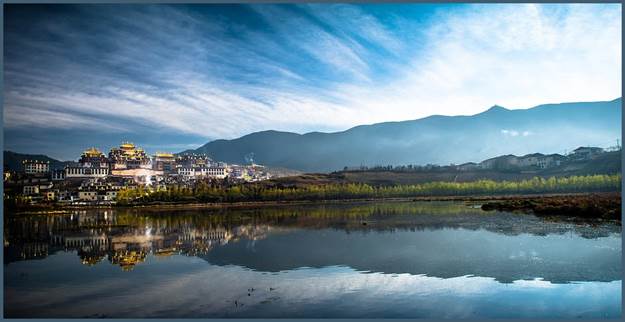
A Temple on the Tibetan Plateau
Unit
Overview
To
help us identify and organize the world in which we live, geographers divide
the Earth’s surface into various regions.
They define some regions by physical characteristics, such as landforms
or climate. Others are based on cultural
or economic similarities. In this unit,
you will see how geographers use certain criteria to classify and compare
places and people. Let’s get started!
What
Makes a Region a Region?
Since
so many places occupy the Earth’s surface, geographers divide and organize the
world into regions. A region is made up of several areas that
have at least one thing in common or something that sets them apart from other
places. It can be as small as a neighborhood
or span several continents. For example,
a group countries that make up a region may share a common landform, such as a plain a plateau, a mountain range, a valley, or
a desert. Another area may be considered
a region because the people who live there have similar religious beliefs and
traditions. The map below shows one way
in which geographers have divided the Eastern Hemisphere into major
regions.
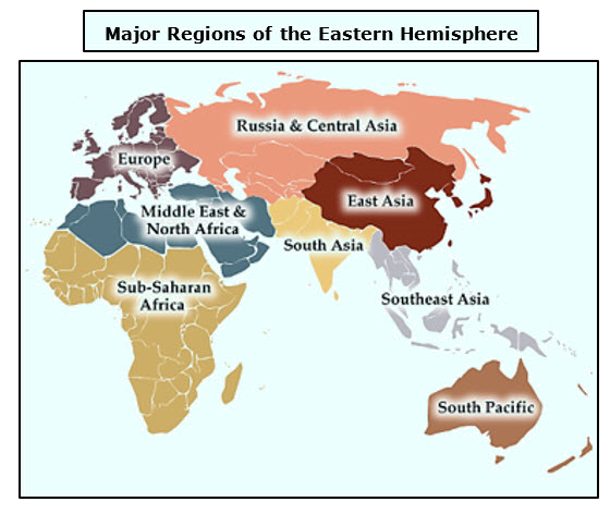
Map Courtesy of the University of Michigan Library
Research Guides
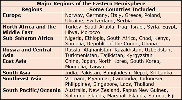
Geographers
create regions to help us manage and interpret the Earth’s surface. This enables us to organize information about
places, people, and environments. For this reason, a region is a human construct, a tool designed by humans to improve our understanding
of the world in which we live. The table
pictured here names some of the countries located within the major regions of
the Eastern Hemisphere. However, it is
important to remember that not all geographers agree on the best way to make
these divisions.
Physical
Regions
Picture
the Earth with no buildings, cities, or other structures made by humans. What would you use to organize the world into
areas that share common characteristics?
One way is to rely on physical features,
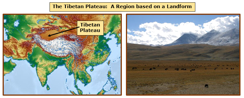
such as landforms, climate, plants and wildlife. The Tibetan
Plateau, located in western China, is one example of a physical region
based on a landform. A plateau is a large, mostly flat area
that is higher than the land surrounding it.
It is bordered on one or more sides by steep cliffs or slopes. The Tibetan Plateau lies north of the
Himalayan Mountains and is the world’s highest plateau. It is the central, unifying feature of the
Tibetan Region. The topographic map
below shows the region shaded in light brown.
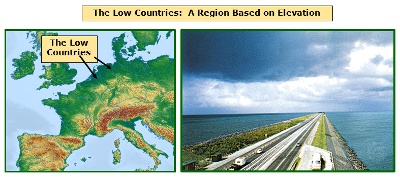
Just
as the Tibetan Plateau is classified as a region because of its uniquely high
elevation, an area in Western Europe is considered a region because of its
uniquely low elevation. The Netherlands,
Belgium, and Luxembourg are often referred to as the Low Countries for this reason.
Much of the land, which lies just off the North Sea, is either below or
at sea level. Because this is a feature
that sets this area apart from other places, the Low Countries are classified
as a region. The topographic map below
shows these areas shaded in dark green.
Geographers
also use physical aspects to compare conditions within specific countries. The map below, for example, shows the climatic regions of Russia.
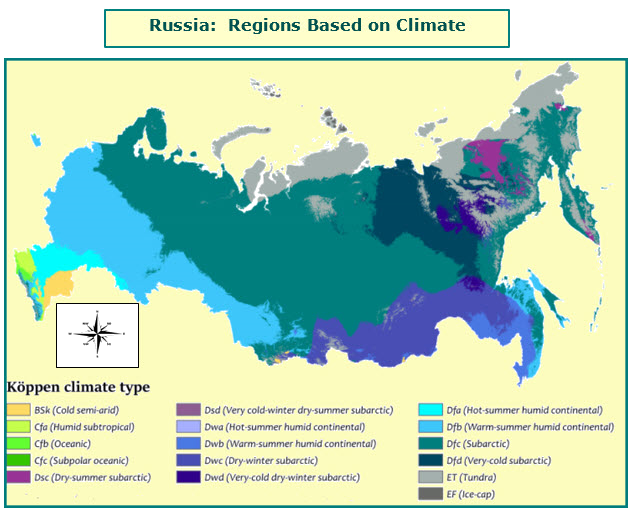
Map Courtesy of
Adam Peterson
The
video listed below shows how geographers have divided the continent of Africa
into several regions based on unique physical features, such as the world’s
largest deserts, a major rainforest, coastlines and climate.
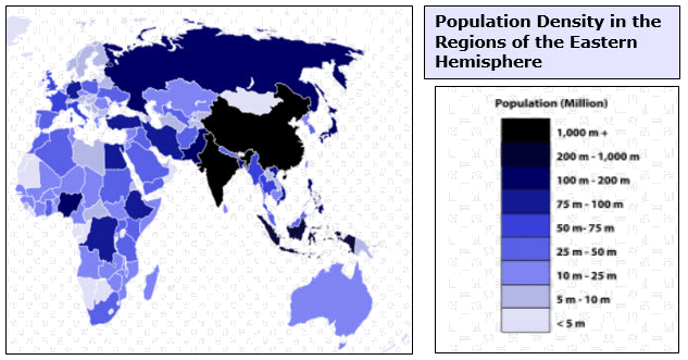
Other
Types of Regions Based on Population, Culture, and Economies
Today’s
geographers separate the world into various regions to help us understand other
populations, cultures, and economies.
Regions based on populations
provide information to compare and analyze birth
rates (the number of live births each year per 1,000 people), death rates (the number of deaths each
year per 1,000 people), the size of families and other factors concerning how
people live. This data helps regions to
plan for the future and anticipate the needs of the population. The map below shows the population density of
the regions in the Eastern Hemisphere.
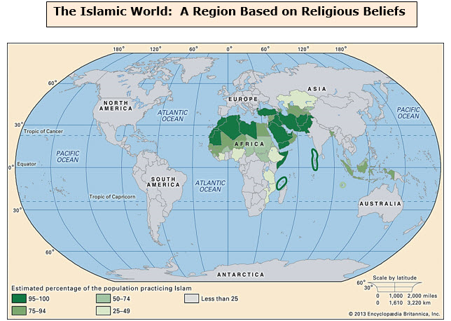
Cultural regions are based on a
wide variety of characteristics. Some
areas are classified as cultural regions because the people who live there
share the same ideas about government or speak a common language. Others are considered cultural regions
because their inhabitants dress the same way, cook the same foods, or live in
the same style of homes. The Islamic World, displayed on the map
below, is a cultural region in which people share the similar religious
beliefs.
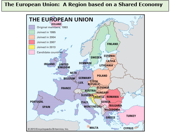
Because
it defines how people produce and distribute goods and services, the economy of a certain area is another
basis for creating a region. The European Union is one example. Countries that are members of this
organization use the same money, agree to charge the same taxes on products, and
make it easy to cross borders. Since
this group of nations shares the same economic concerns, the European Union is
not only classified as an organization but also as a region. You can see this region displayed on the map
below.
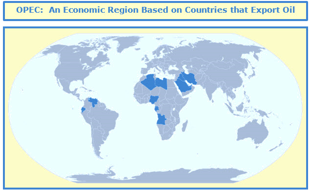
The Organization of Petroleum Exporting
Countries, or OPEC,
is another organization that some geographers classify as an economic
region. OPEC members depend on petroleum
exports to support their economies. For
this reason, they try to keep the price of oil on the world market stable by
regulating the amount that they ship to other countries. If oil-exporting countries offer too much of
their product for sale, there is less competition. Buyers pay less, and profits decrease. On the other hand, if oil-exporting countries
offer a much smaller amount of oil for sale, competition increases, and buyers
are forced to pay higher prices.
Although this increases profits in the short-term, it encourages buyers
to look for ways to purchase less from OPEC nations in the long-term. The map below displays in blue the economic
region based on OPEC.
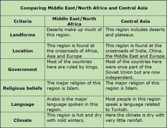
Comparing
Regions
Geographers
use certain criteria, or standards,
to establish regions. They also use
these same guidelines when they contrast or compare one region to another. The table below shows similarities and
differences between the regions of Central Asia and Western Asia/North
Africa. In this case, the criteria are
location, landforms, government, language, and climate.
Time
for a Quick Review
Before
moving on to Unit 4, take a few minutes to review the terms found in Unit
3. Be sure that you can answer the “Can
I” questions listed below with a loud “yes”.

Additional Activities and Resources