Course
Overview
Welcome
to Social Studies 160! In this course,
you will focus on the people and places of the Eastern Hemisphere, including
Asia, Africa, Australia, and Europe. You
will also learn about the unique, early civilizations that developed in these
regions and their enduring impact on the modern world. How do the people of the Eastern Hemisphere
govern themselves? How does the movement
of people, products, and ideas from one part of the globe to another affect
their lives? You will also study your
role as a consumer in a market economy along the effects of scarce resources,
competition, supply, and demand. Let’s
get started!
UNDERSTANDING THE GLOBE

Globe Showing
the Eastern Hemisphere on the Right
Unit
Overview
Because
this course emphasizes the Eastern Hemisphere, it is important to know exactly
what this term means. We begin by
looking at the globe, one of the most important geographic tools. You will see how cartographers divide the
world into hemispheres by using two sets of imaginary lines. They use these same lines to create addresses
that help us to find countries, cities, and landmarks easily and
efficiently. Let’s see how it all works!
Longitude
and Hemispheres
You
will spend much of your time in this course learning about the people and
places located in the Eastern Hemisphere.
Where is the Eastern Hemisphere?
What regions of the world does it include? An easy way to understand what we mean by the
Eastern Hemisphere is to look at a globe. Hemisphere
comes from Greek words that mean half of
a sphere. In this case, the sphere
is a representation of the Earth, or a globe. A globe shows us the location of places on
the Earth. It is one of many geographic tools that we use to gather
information about places, people, and environments. Globes come in a wide variety of sizes and
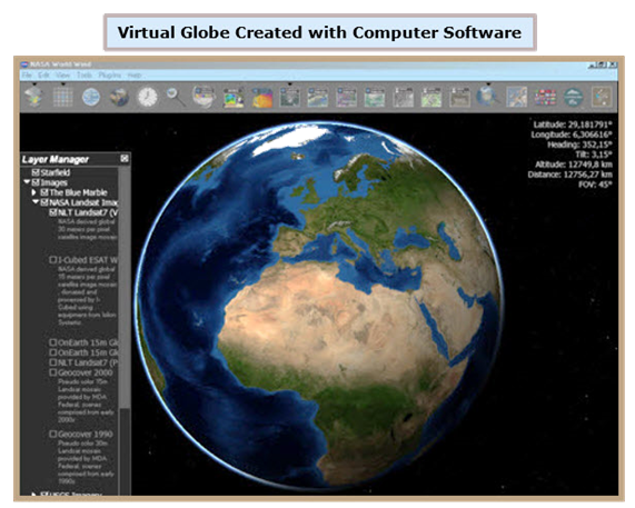
styles. Today, they also are found in
virtual forms, such as the one pictured below.
It was created through computer software developed by the National
Aeronautics and Space Administration (NASA).
To
locate places accurately, map-makers, also called cartographers, developed a system of imaginary lines that
crisscross globes and maps. The lines
that run up and down between the North and South Poles are known as lines of longitude. They are also called meridians, and the distance between them becomes smaller in the
areas closest to the Poles. One line of
longitude is marked at zero degrees (0°).
This is the Prime Meridian. Because the Prime Meridian passes close to
Greenwich, a town just outside of London in the United Kingdom, it is sometimes
called the Greenwich Line.
All
lines of longitude west (left) of the Prime Meridian are numbered from 1° to
179° and are followed by a W. This part
of the Earth is the Western Hemisphere. The United States, Canada, and Mexico are some
of the countries located here. All lines
of longitude east (right) of the Prime Meridian are numbered from 1° to 179°
and are followed by an E. This part of
the Earth is the Eastern Hemisphere. China, India, and South Africa are some of
the countries located here.
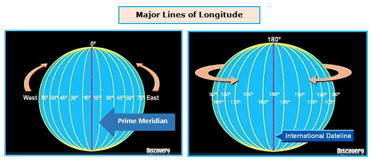
The
Eastern and Western Hemispheres extend in opposite directions from the Prime Meridian
for 179° to the other side of the globe.
At 180°, there is a line of longitude, which runs mostly over the
Pacific Ocean between the North and South Poles. It is called the International Dateline. Unlike
other meridians, it is not labeled with a W or an E. If you travel east across the Eastern
Hemisphere and cross the International Dateline, you will find yourself in the
Western Hemisphere. If you continue in
the same direction until you cross the Prime Meridian, you will re-enter the
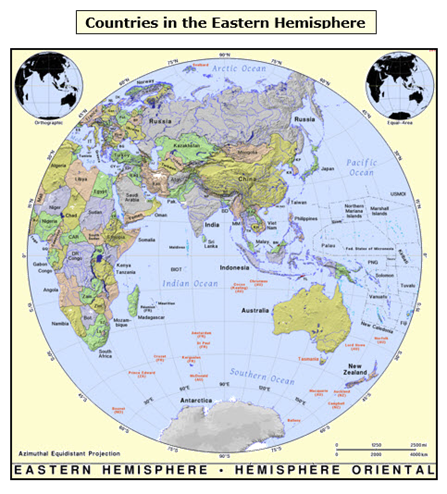
Eastern Hemisphere. The section of a
globe pictured below will give you an idea of the wide variety of lands and
people that make up the Eastern Hemisphere.
Latitude
and Hemispheres
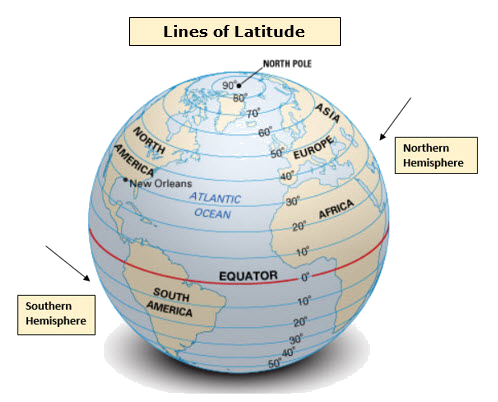
Cartographers
developed another set of imaginary lines that form circles around the Earth
from east to west. These are called lines of latitude. The most important line of latitude is the Equator. Picture it as a belt that ties at the Earth’s
waist. It is located halfway between the
North and South poles and is designated as 0°.
Other lines of latitude are labeled from 1° to 90° as they move away
from the Equator toward the poles. Because
they are parallel to the Equator, lines of latitude are also called parallels. Cartographers label parallels north of the
Equator with an N and those south of the Equator with an S. The region above (north) the Equator is
referred to as the Northern Hemisphere,
while the region below (south) the Equator is referred to as the Southern Hemisphere.
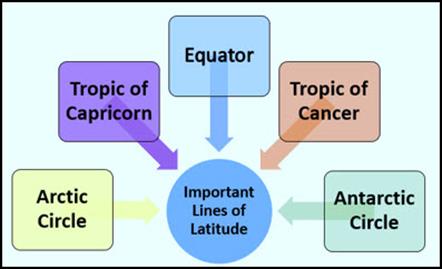
Along
with the Equator, there are four additional lines of latitude that are
important. They not only help us to
locate places but also tell us what to expect in terms of the weather, the
hours of sunlight, and seasonal changes.
Ø The Tropic of Cancer:
The Tropic of Cancer is located 23½° north of the Equator. It is the northernmost point that the sun
appears directly overhead. Once a year,
the Sun shines directly over this imaginary line. When this happens, it is the first day of
summer in the Northern Hemisphere and the first day of winter in the Southern
Hemisphere.
Ø The Tropic of Capricorn: The Tropic of Capricorn is 23½° south of the
Equator. Like the Tropic of Cancer, it
is named for a constellation. The Tropic
of Capricorn is the southernmost point that the sun appears directly
overhead. Once a year, the sun shines
directly over this imaginary line. When
this happens, it is the first day of winter in the Northern Hemisphere and the
first day of summer in the Southern Hemisphere.
Ø The Arctic Circle:
The Arctic Circle is located 66½° north of the Equator. When it is winter in the Northern Hemisphere,
the sun does not rise here, but it shines continuously during the summer.
Ø The Antarctic Circle:
The Antarctic Circle is located 66½° south of the Equator. When it is winter in the Southern Hemisphere,
the sun does not rise here, it but shines continuously during the summer.
The
lands between the Tropic of Cancer and the Tropic of Capricorn are known as the
tropics. They experience very warm temperatures and
little seasonal change throughout the year.
Although areas within the Arctic and Antarctic Circles also experience
little in the way of seasonal change, they are subject to very cold
temperatures year round.
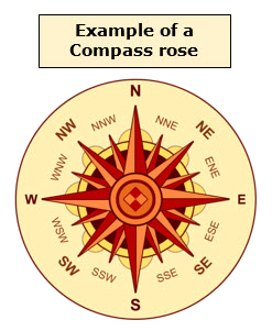
Locating
Places on the Globe
The
main purpose of a globe is to show where things are on the Earth. One way to describe the location of a place
is to compare it to somewhere that you already know. You can then note that it is north, south,
east, or west from a certain point.
These types of directions are known as cardinal directions, and they are the most common way to explain a
location. Globes and maps usually
include a compass rose, like the one
pictured below, for this reason. This
compass rose also includes intermediate
directions, such as northeast, southeast, southwest and northwest. For example, if someone asked you for
directions to the nearest public library, you might tell them to turn left at
the next traffic light and to continue walking three blocks south. This kind of description is called relative location because you related
them to, or based them on, the person’s current location. On a bigger scale, if a friend asked you to
help him find Mexico on the globe, you would probably remind him that it is
south of the United States.
When American students study the Western Hemisphere, they already know where many major cities, rivers, and landforms are. However, in this course, you will be studying regions located in the Eastern Hemisphere. It is likely that you will be looking for cities and countries whose names you may not recognize. This makes it difficult to rely on relative location. Fortunately, geographers have developed a system that gives us an exact address, or absolute location, of every place on the Earth. Remember—the imaginary lines of longitude and latitude crisscross to create a grid on the globe.
Lines
of longitude run from pole to pole beginning at the Prime Meridian. Lines of latitude circle the globe fanning
out from the Equator. The absolute
location of any place on the planet can be identified by the position where a
parallel of latitude and a meridian of longitude meet. The numbers of these lines make up the geographic coordinates that identify
specific locations on maps and globes.
In other words, they represent addresses and direct us to exact sites,
just as house numbers and zip codes do.
Geographic coordinates begin with the number of a parallel followed by N
for north or S for south. The other half
of the coordinate is the number of a meridian followed by E for east or W for
west. Study the examples below.
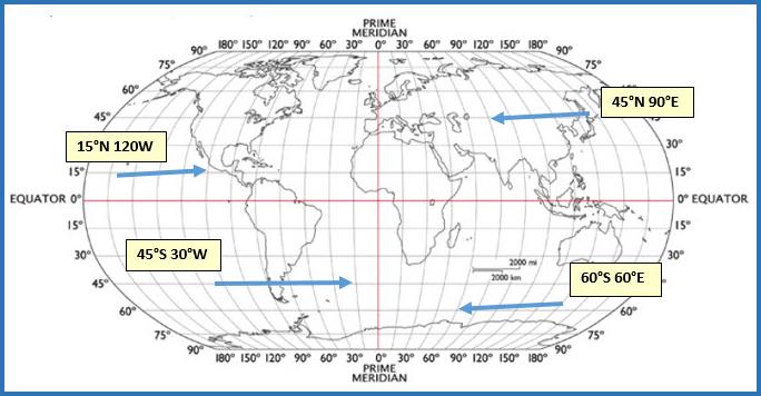
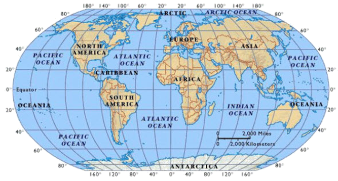
Now,
let’s look at some examples on a map that displays oceans and continents along
with lines of longitude and latitude. If
you wanted to swim in the Pacific Ocean, which of these coordinates on the map
below indicate the better location--40°S 140°W or 40N° 100°E? If you said 40°S 140°W, you are correct! The other coordinates would be a good choice
if you wanted to hike across the continent of Asia. How about a swim in the Atlantic Ocean—40°N
60°W or 0° 60°E? If you chose the first
coordinates, you are right! You would
find yourself swimming in the Indian Ocean if you chose the second pair. If you travel to 80°S 80°E, should you take
coats and boots or shorts and flip-flops?
Since these coordinates place you in Antarctica, you definitely want
your cold-weather gear here. Save the
beach wear for 20°N 80°W!
Learn more about relative and absolute
location by watching the videos listed below.
Time
for a Quick Review
Before
moving on to Unit 2, take a few minutes to review the terms found in Unit
1. Be sure that you are also able to
answer the “Can I” questions listed below with a loud “yes”!


Additional Activities and Resources