MAPS AND DIRECTIONS
Unit Overview
In this unit, students will be learning that a map scale and cardinal and intermediate directions can be used to describe the relative location of physical and human characteristics of Ohio and the United States.
Fourth-grade students describe the relative location of the physical and human characteristics of Ohio and the United States using a map scale and cardinal and intermediate directions. Students can describe relative location by using the map scale to approximate the distance between places. Cardinal and intermediate directions also can be used to describe relative location, such as Dayton is west of Zanesville or Virginia is southeast of Ohio.
Maps:
A map is a representation or a drawing of the earth’s surface or a part of it drawn on a flat surface according to a scale. We find that maps are useful to us for various purposes.
Maps can be used to show the physical features of the Earth (mountains, plains, oceans, rivers, etc.), the political divisions of the Earth (countries, states, cities, etc.), and certain specific information (roads, rainfall, forests, industries, etc.)
Maps can be used for representing large areas like continents or countries (large scale maps), and also for representing a small area like a village or a town (small scale maps).
Video: Watch this BrainPOP video to learn about maps and how to use them.
Quiz: Take this BrainPOP quiz after viewing the video above.
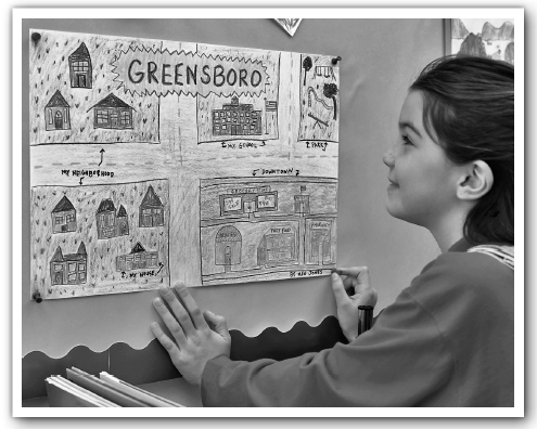
Look at the below picture of a student-drawn map of her neighborhood, school, and house. Maps reveal the spaces of our lives.

Maps can be used to describe the relative location of physical and human characteristics of Ohio and the United States. Refer to a map of Ohio and find these items:
A body of water: ___________________________________
Mountains: ________________________________________
A city: ____________________________________________
A road: ___________________________________________
Capital city: _______________________________________
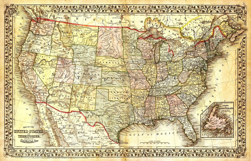
Map of the U.S.A.:
Map Scale:
Map scale - shows the relationship between a unit of length on a map and the corresponding length on the Earth’s surface. A map scale is a way of describing how much space in real life a certain amount of space on a map represents. For example, maybe an inch on a map is equal to a mile in real life. You find this out by looking for a legend or a key. This legend or a key is a line or bar near the edge of the map, which is a physical representation of the scale. That line should have markers showing a particular distance and numbers to tell you how far that is in real life.
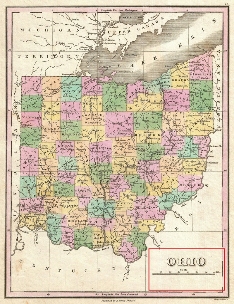
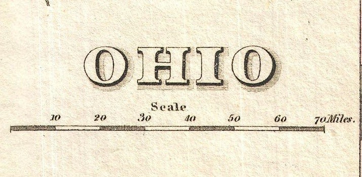
Map of Ohio and close up view of the Map Scale
Let's practice!
Put yourself in this scenario: Three wall maps were taped side by side to the chalkboard at the front of the room. One is a Mercator projection, one a Winkel, and one a Peters. “This is the United States,” the teacher said, pointing to the United States on the first map. “Right?” she asked. “Right!” the children cheered. “And so is this and this,” she said as she pointed to the other maps. “Right?” “Right!” “But the shape of the United States is different in each,” she continued. “So is Africa. And Greenland. Why is that? Come have a closer look and tell us what you think.”
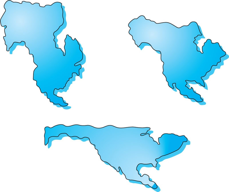
In the three images above, North America is depicted but based on the different map projections, the shape and lay of the land of North America looks different. What does this tell you about maps and their accuracy of what they are trying to represent?
Globes cannot be made into flat maps without distorting shapes or sizes of landforms and water bodies. Different projections get different aspects of the globe right. For instance, the Mercator projection is helpful for sailors to use when navigating ocean travel, the Peters projection gets the proportions of landmasses to one another right, and the Fuller projection gets the landmass sizes (relative to one another) right.
Directions:
Vocabulary:
Cardinal directions - the four main points of the compass (north, south, east and west).
Intermediate directions - the points of the compass that fall between north and east, north and west, south and east, and south and west, i.e., NE, NW, SE and SW.
Relative location - the location of a place relative to other places (e.g., northwest or downstream).
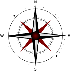
Cardinal directions: (north, south, east and west)
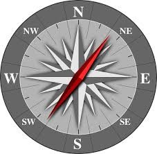
North, South, East, and West are known as the Cardinal directions. They are often represented on a map with a Compass Rose, pictured below:
Let's practice!
Comeplete this Map Practice Worksheet.
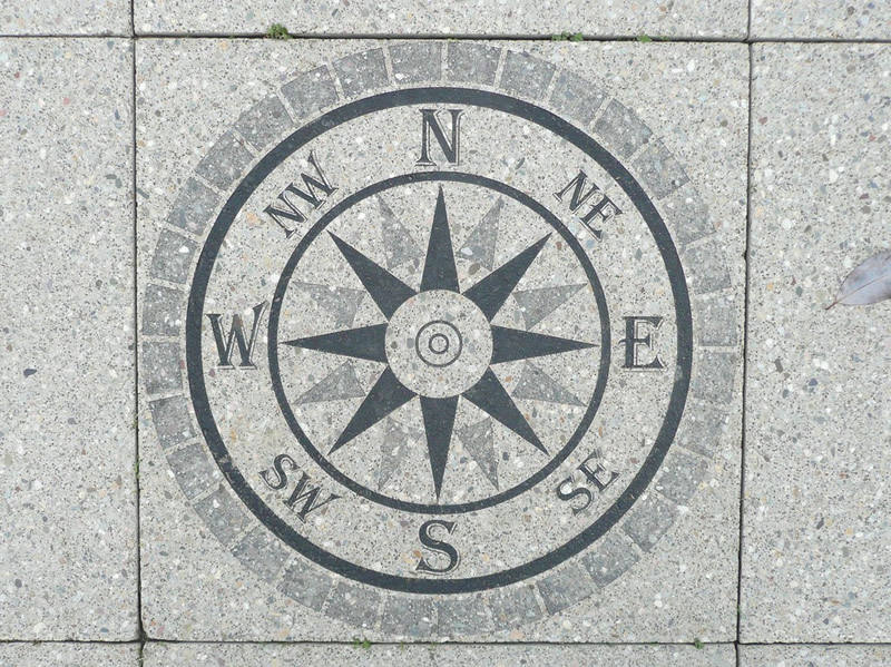
Intermediate directions: (NE, NW, SE and SW)
There are other directions in between the Cardinal directions of North, South, East and West. These in-between directions are known as Intermediate directions. They are Northeast (NE), Northwest (NW), Southeast (SE), and Southwest (SW). The Intermediate directions can also be represented on a Compass Rose as seen below:
Let's practice!
“Find a Friend”
Look at the compass and the grid and answer the questions below by following the directions:
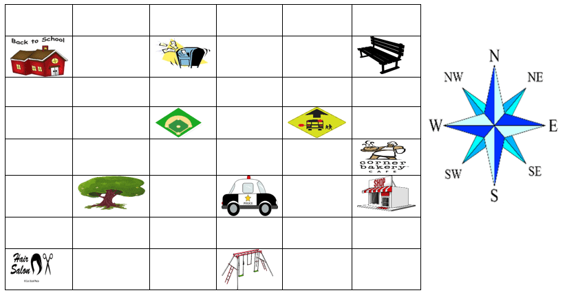
Where will you find your friend?
Where did you find Rick? _______________
Where did you find Margie? _______________
Where did you find Leo? _______________
Where did you find Sally? _______________
Where did you find Alex? _______________
Relative location:
Relative location is when places are described in relation to other objects, items, people or places. For example, in the picture below you could give the location of the pen by describing its location relative to other items in the picture. The pen is to the left of the laptop. It is also to the right of the notepad. You could also say that the pencil is located on top of the table or desk.

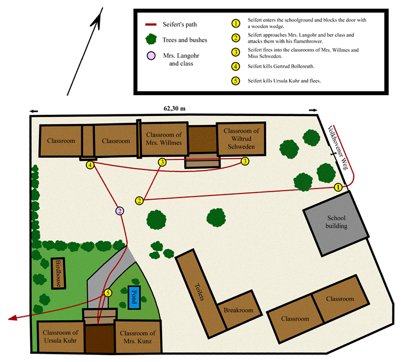
Directions like north, south, east, and west help describe where one place is in relation to another. On the map of a school shown below, you could describe the classroom of Mrs. Wilmes as being to the left of the classroom of Wiltrud Schweden. But because the compass rose in the bottom right corner lets you know the cardinal and intermediate directions, you could also describe the Classroom of Mrs. Wilmes as being to the west of the Classroom of Wiltrud Schweden.
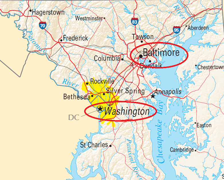
Directions like north, south, east, and west help describe where one place is in relation to another. For example, one way to describe the relative location of Washington D.C. is that it is southwest of Baltimore.
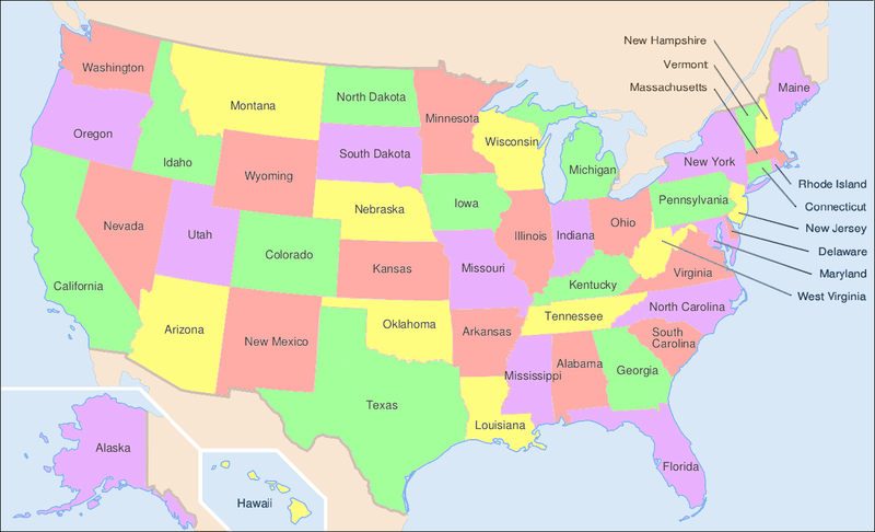
Let's practice! Use the U.S. map below to develop FIVE different ways to describe the RELATIVE location of Ohio. For example, you could say that Ohio is Northwest (NW) of West Virginia.
1.
2.
3.
4.
5.
Review:
After completing this unit, review the following checklist to make sure you can do all of the following:
_I can use a map scale and cardinal and intermediate directions to describe the relative location of physical and human characteristics of Ohio and the United States.
_I can explain what information is provided on a map scale.
_I can define and identify cardinal directions.
_I can define and identify intermediate directions.
_I can explain the concept of relative location.
_I can use cardinal directions to describe relative location.
_I can use intermediate directions to describe relative location.
_I can use a map scale to approximate distances between places.